3. Spheroidal Coordinates
a. Angular
Around 150 BC, Ptolemy created his first world atlas consisting of twenty-seven pages of maps compiled from observation and traveler's stories. His was the first documented use of east-west and north-south grid lines with positions identified by latitude and longitude. It's a system still used today, albeit with a more accurate representation of the Earth than was possible for Ptolemy.
Latitude and longitude are angular values, one north-south, the other east-west, from two reference planes.
Latitude, Φ, is the angle in the meridian from the Equatorial plane to the normal line at the observer's position. Latitude ranges from 90° South to 90° North (-90° to +90°).
Longitude, λ, is the angle in the Equatorial plane from a reference meridian to the observer's meridian. Longitude varies from 0° to 180° East for the eastern hemisphere; 0° to 180° West for the western hemisphere. Historically the reference meridian used depended in part on the mapmaker's native country - many countries had their own defined by a significant location. Ptolemy's was located in the Canary and Maderia Islands. Others were in Rome, Copenhagen, Jerusalem, Paris, Philadelphia,... Today the Greenwich Meridian is generally used as the 0° longitude line.
On a sphere the normal is radial from the sphere's center, Figure C-6. These latitudes and longitudes are generally referred to as geocentric or geographic coordinates.
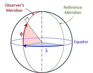 |
| Figure C-6 Geographic Coordinates |
On an ellipsoid the normal intersects somewhere along the semi-minor axes, Figure C-7. These latitudes and longitudes are geodetic coordinates.
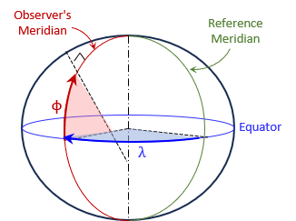 |
| Figure C-7 Geodetic Coordinates |
While geographic and geodetic coordinates are defined similarly and their values at a point would be very close, they are in fact different. The surveying and mapping community uses geodetic coordinates.
A point's absolute 2D position can be expressed with its latitude and longitude. Its 3D position can be expressed by adding the height abovre the ellipsoid.
b. Linear
Latitude and longitude isn't a convenient system to measure or compute in nor are unit lengths consistent. For example, one degree of longitude at the equator is much longer than one degree at 60° N latitude, and non-existent at 90°N latitude.
An alternative global system is the Terrestrial Reference System (TRS) also known as the Earth-Centered Earth-Fixed (ECEF) system. This is a three-axis linear system with the original at the Earth's mass center, Figure C-8.
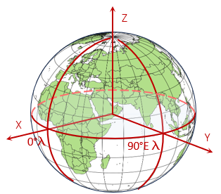 |
| Figure C-8 Terrestrial Reference System |
The X and Y axes are in the Equatorial plane with X passing through the Greenwich Meridian and Y through 90°E longitude. The Z axis is perpendicular to the Equatorial plane and positive through the North Pole.
A point's 3D position is given by its (X,Y,Z) coordinates.
Although TRS is a linear system, it is not convenient for surveying or mapping applications because of coordinate magnitudes. For example, the coordinates of a control point in southcentral Wisconsin is 21,919.631m X, -4,679,204.603m Y, 4,320,134.562m Z. Their size makes them cumbersome to work with.
Another issue, though less serious, is mapping vertical objects. To map a tall building we generally locate its footprint and assume the upper structure falls within it (unless there are significant protuberances). In the TCS, the top of a building has different coordinates than its bottom. Take for example the TV tower in figure C-9.
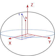 |
| Figure C-9 Mapping a Tower in TRS |
Although its height is exaggerated, Figure C-9 clearly demonstrates that the top (t) and bottom (b) have different coordinates.
c. Converting coordinates
Equations C-4, -5, and -6 are used to convert geodetic to TRS coordinates:
| |
Equation C-4 |
| |
Equation C-5 |
| |
Equation C-6 |
where:
| Φ, λ | Point latitude and longitude; west longitude is a negative value. | |
| h | Ellipsoidal height; distance to point from the ellipsoid along the normal. | |
| N | Radius in the prime vertical (discussed in next section) | |
 |
Equation C-7 | |
| e | Ellipsoidal eccentricity | |
Equations C-8 through -12 convert TRS coordinates to geodetic:
| Equation C-8 | |
| Equation C-9 | |
| Equation C-10 | |
| Equation C-11 | |
| Equation C-12 |