3. Orthometric Height Leveling Error
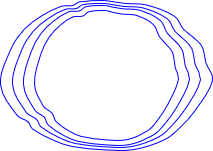
The geoid isn't the only equipotential surface - any level surface is one also.
 |
|
Fig D-14 |
The configurations of level surfaces are similar to the geoid - irregular, flattened at the poles and enlarged around the equator. Though they share similar behavior, they are not trully parallel with each other.
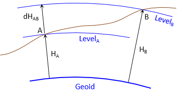
Let's examine a differential level circiut running from A to B, Figure D-15.
 |
| Figure D-15 Differential Level Run |
The elevation difference from A to B is the difference between the BS reading sum and FS reading sum:
| |
Equation D-1 |
| |
Equation D-2 |
This is based on level surfaces being parallel, either flat planes (plane surveying) or concentric curved surfaces (geodetic surveying).
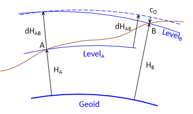
However because level surfaces are irregular and converge toward the poles the vertical spacing between them is not constant.This will introduce an error in elevations determined by differential leveling.
Over distances typically covered by differential leveling runs, the irregularity between level surfaces is generally less than their convergence. The orthometric correction, cO, is the amount the surfaces converge along the run, Figure D-16.
 |
| Figure D-16 Converging Level Surfaces |
The ending elevation is corrected by adding the orthometric correction to it.
| |
Equation D-3 |
| Equation D-4 |
| where: | ||
| φ | Start point latitude | |
| H | Start point orthometric height | |
| Δφ' | Latitude difference, (φend-φstart); expressed in minutes | |
The orthometric correction only affects level runs having a north-south component; Δφ' is zero for strictly east-west runs.
Equation D-4 is set up to return the correct mathematical sign on the correction depending on the run direction. The units for cO are the same as those of HAvg.
Example
A differential level circuit is run from point Kollath (elev = 1139.62 ft) to point JM4. The elevation difference along the run is -379.10 ft. The approximate geodetic coordinates of both points are:
| Point | Lat | Long |
| Kollath | 42°57'28.6" W | 89°37'38.3" N |
| JM4 | 42°54'00.7" W | 89°37'51.9" N |
Determine the orthometric correction at point JM4.

This will effect a circuit run with a three-wire level or parallel-plate micrometer. And it will have a cumulative effect on successive runs..