Chapter N. Conversions and Transformations
1. Tomato - Tomahto
Although not universally accepted, there is a distanct difference between a coordiate conversion and a coordinate transformation. Each is a process of changing a point's coordinates from one system to another. The difference is in how that is accomplished and if errors are introduced.
2. Conversion
a. Defined
A conversion is based on an exact and rigorous mathematical relationship between the two coordinate systems. When a position is converted no error is introduced beyond that already in the source coordinates. If the source positions are good to ±0.1 ft, then so are their converted results. The position accuracy is neither increased nor degraded.
b. Forward and Inverse conversions
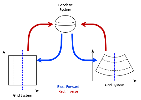
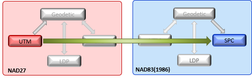
State Plane coordinates (SPC) and Universal Transverse Mercator coordinates (UTM) projection systems are linked mathematically directly to the ellipsoid. A point position can be expressed in geodetic coordinates (latitude and longitude) or grid coordinates (N/E, X/Y).
A Forward conversion creates grid coordinates from geodetic; an Inverse conversion creates geodetic from grid. The process is shown graphically in Figure N-1.
 |
| Figure N-1 Geodetic-Grid Conversions |
What if a user had UTM coordinates of a point and wanted its SPC? Each grid is mathematically connected to the ellpsoid. None are directly tied to a another grid system. To convert UTM to SPC is a two-step process. Refer to Figure N-1:
(1) Inverse conversion from UTM to Geodetic (red arrow)
(2) Forward conversion from Geodetic to SPC (blue arrow)
UTM and SPC are independently defined so there is no rigorous link between them.
Forward and inverse conversions and their combinations are exact within a datum, Figure N-2.
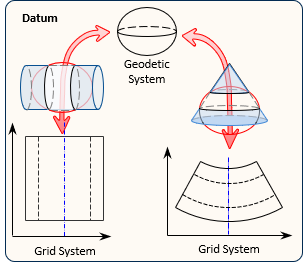 |
|
Figure N-2 |
3. Transformation
A transformation is used when there is no rigorous mathematical connection beteween the two systems. This happens when the position change behavior between the two systems is not systematic. A mathematical model is used to approximate the behavior. The model may be simple or complex and may emphasize specific characteristics over others. For example, a conformal transformation maintains angular relationships between lines to the detriment of line lengths.
A transformed position will have error in the resultant coordinates. The degree of error is a function of the model used, how large an area it covers, and where the positions are located.
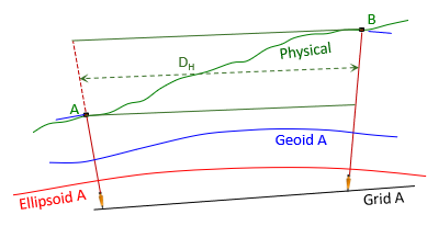
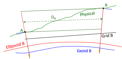
Recall from XII. Geodesy Chapter G. The North American Datum that positional shifts from NAD27 to NAD83 were not uniform in behavior or magnitiude. This was due to a new ellipsoid that was fit differently and a readjustment that included 10 times as many control proints.
A major concern with NAD83 adoption was how to migrate positions from NAD27. The lack of an exact mathematical connection between datums meant migrated positions would be subject to error. Subsequent readjustments of NAD83 incorporated new control points with more measurements and removal of lower quality legacy measurements. While not as dramatic as those of NAD27 to NAD83, position differences were not systematic between datums. A datum-to-datum position change requires a transformataion, Figure N-3.
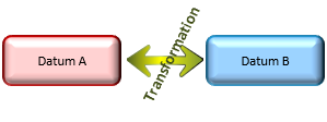 |
| Figure N-3 Datum-to-Datum |
Transformations are not limited to datum-to-datum applications. A project-based coordinate system may require a transformation to connect to a UTM or SPC grid. Coordinates measured on an aerial photograph generally need to be transformed into a ground or grid system. Unless the source system is directly connected to the final system at the onset, moving coordinates from one to the other will involve a transfomation.
Common 2D transformations are discussed in Topic IX. COGO Chapter J. Coordinate Transforamtion.
4. Datum-to-Datum Grids
A conversion is within a datum, between datums is a transfromation.
To go from grid coordinates on one datum to grid coordinates on another can be done one of two ways.
a. Through geodetic positions
Figure N-4 shows the process which combines two conversions and one transformation.
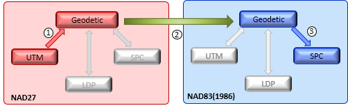 |
| Figure N-4 UTM NAD27 to SPC NAD83(1986) |
This method has three steps:
- Convert UTM coordinates to Geodetic on NAD27
- Transform NAD27 Geodetic coordinates to NAD83 Geodetic
- Convert NAD83 Geodetic coordinates to SPC
Steps 1 and 3 do not introduce position error, step 2 does.
b. Direct Grid-to-Grid
We could build a model to perform a transformation directly between both grid coordinates systems, Figure N-5.
 |
| Figure N-5 Direct Grid-to-Grid |
Because this is a 2D situation, to build a model requires at lease two points whose positions are known in both grid systems. Three or more allow a least squares solution which can indicate expected uncertainties in the transformed positions.
Model criteria is left entirely to the user. Using transformation software enforcing various conditions allow investigation of differnt options from which the "best" can be selected for the situation.
5. Software
a. Conversion
Grid to and from Geodetic coordinates software is available from a number of sources and is incorporated in many mapping and GIS packages. They are based on published equations so results can be replicated regardless the platform. An example is the NAD83 Coordinate Conversion worksheet in the Software section.
b. Transformation
A large selection of transformation software is available based on different models and transformation conitions. TransPack is a simple package consisting of three main transformation types: conformal, affine, and projective. Becasue there are so many transformation conditions that can be applied, there is no single best mathematical model for all transformations. Experimentation, sometimes difficlut to replicate, may be necessary.
c. NGS
NGS which was responsible for the datum update as well as the national network's records mordernization, developed transformation and conversion tools to help users move to the new datum. All the individual software programs were part of their Geodetic Tool Kit.
(1) Conversion
Prior to NAD83 creation, NGS developed a range of programs to perform forward and inverse convesions for SPC and UTM. Their equivalents were created post-NAD83.
(2) Transformation
NGS' initial product was LEFTI (LEast Squares Fitting Tranfornation and Interpolation) developed primarily for the USGS to determine updated map corner locations. A series of 7.5 minute quadrangle maps were published with the shifted map corners printed in their correct spatial positions. LEFTI while accuate enough at the 7.5 minute topoquad scale was insufficient for large scale uses. Its life was relatively short.
The next product, and one of the best known, was NADCON (North American Datum CONversion) [it was unfortunate that NGS used "conversion" in the name of a transformation program]. Many GIS/Mapping software packages incorporated NADCON. NADCON was updated throught the NAD83(HARN) readjustment
LEFTI and NADCON were limited to (1) 2D positions, (2) Geodetic coordinates, and (3) NAD27 to NAD83(86) transformation.
Next chrolnologcally were GEOCON (GEOdetic CONversion) and GEOCON 11. These differed in that they were 3D (including ellipsoid height) and addressed specific readjustments: GEOCON transformed from NAD83(HARN) to NAD83(2007), GEOCON 11 from NAD83(2007) to NAD83(2011).
By this point, it was getting to be a bit of a mess. If you wanted to transform a NAD27 UTM position to NAD83(2011) using NGS products you had to follow this process:
- Convert NAD27 UTM grid coordinates to NAD27 geodetic coordinates
- Use NADCON to transform the NAD27 geodetic coordinates to NAD83(HARN)
- Use GEOCON to transform the NAD83(HARN) geodetic coordinates to NAD83(2007)
- Use GEOCON 11 to transform the NAD83(2007) geodetic coordinates to NAD83(2011)
- Convert the NAD83(2011) geodetic coordinates to NAD83(2011) SPC grid coordinates.
Not very efficient, regardless of which datum/adjustment you started at.
(3) Combined Operations
Sidebar
NGS developed VERTCON (VERTical CONversion) which was the vertical transformation equavalent of NADCON. Not long after it was released the US Army Corps of Engineers developed CORPSCON. CORPSCON combined NADCON with VERTCON and added coordinate conversion front- and back-ends. Input and output coordinates could be any combination of SPC/ UTM, or Geodetic. CORPSCON was the first readily available 3D datum-to-datum conversion/transformation software. Its last version was 6.0 and was officially retired in 2023.
NGS replaced their conversion and NADCON/GEOCON products with NCAT (NGS Coordinate Conversion And Transformation Tool). This online tool can transform between any datum/adjustment (horizontal and vertical) up to the most current one and convert between coordinate types on any datum (NGS finally got "conversion" and "transformation" right). For the previous UTM NAD27 to SPC NAD83(2011) example, the user just has to provide:
- Source coordinates, type, and datum/adjusment
- Final coordinate type and datum/adjustment
NCAT automatically performs all the necessary conversions and transformations. In addition to SPC and UTM grid, NCAT can also convert to/from Earth Centered Earth Fixed (ECEF) X-Y-Z and US National Grid.
NGS is expected to further develop NCAT when the new datums and grid systems arrive in the c2026 time frame.
6. Summary
While there aren't many users who are still trying to bring NAD27-based positions into the current datum/adjustment, there are those having positions based on later realizations who need to bring them forward. They face the same conversion-transformation issues regarding accuracy - where are errors introduced in the process? Most GIS/Mapping software transparently perform these operations automatically. The user may not be aware of any issues until the positions are integrated with other spatial data.
NCAT is considered the "official" way to move positions between datums. Besides flexible input/output formats its advantages include a stable datum-datum transformation core. Its primary disadvantage may be its macroview transformation. For a small project area a traditional tranformation may model datum-to-datum position differences better. It depends on the user's accuracy needs.
From a strictly surveying perspective, the best method to change positons between datums is to not use NCAT or any other transformation software. Ground measurements are independent of grid systems and ellipsoids. Ground measurements are reduced to grid depending on the grid sysytem, ellipsoid, and ellipsoid fit. The position accuracies are dependent on the measurement accuracies. The most accurate way to determine SPC NAD83(2011) positions of SPC NAD27 positions is to reduce the same ground data to SPC NAD83(2011). This works for any grid system on any datum/adjustment, Figure N-6. Determining positions this way also provides a data set against which NCAT or any conversion/transformation process can be tested.
 |
| (a) Reduction to Datum A |
 |
| (b) Reduction to Datum B |
| Figure N-6 Same Data, Different Datum |
Of course, this requires access to the original ground measurements which shouldn't be a problem for most surveyors as we record those in our fieldbooks and/or data collectors and archive them (you do archive your measurements, right?). This isn't the case for other spatial data collectors so they must rely on software.
Bottom line: ground truthing should be part of any project that has defined accuracy needs. As easy and quick as GPS positioning is, there is no excuse not to.