6. Summary
While there aren't many users who are still trying to bring NAD27-based positions into the current datum/adjustment, there are those having positions based on later realizations who need to bring them forward. They face the same conversion-transformation issues regarding accuracy - where are errors introduced in the process? Most GIS/Mapping software transparently perform these operations automatically. The user may not be aware of any issues until the positions are integrated with other spatial data.
NCAT is considered the "official" way to move positions between datums. Besides flexible input/output formats its advantages include a stable datum-datum transformation core. Its primary disadvantage may be its macroview transformation. For a small project area a traditional tranformation may model datum-to-datum position differences better. It depends on the user's accuracy needs.
From a strictly surveying perspective, the best method to change positons between datums is to not use NCAT or any other transformation software. Ground measurements are independent of grid systems and ellipsoids. Ground measurements are reduced to grid depending on the grid sysytem, ellipsoid, and ellipsoid fit. The position accuracies are dependent on the measurement accuracies. The most accurate way to determine SPC NAD83(2011) positions of SPC NAD27 positions is to reduce the same ground data to SPC NAD83(2011). This works for any grid system on any datum/adjustment, Figure N-6. Determining positions this way also provides a data set against which NCAT or any conversion/transformation process can be tested.
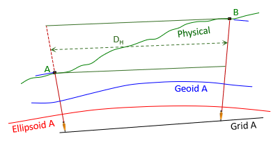 |
| (a) Reduction to Datum A |
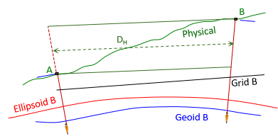 |
| (b) Reduction to Datum B |
| Figure N-6 Same Data, Different Datum |
Of course, this requires access to the original ground measurements which shouldn't be a problem for most surveyors as we record those in our fieldbooks and/or data collectors and archive them (you do archive your measurements, right?). This isn't the case for other spatial data collectors so they must rely on software.
Bottom line: ground truthing should be part of any project that has defined accuracy needs. As easy and quick as GPS positioning is, there is no excuse not to.