Page 3 of 5
3. Jurisdictional Boundaries
Even though zones are based on mathematical projections,their boundaries generally coincide with counties or parishes. For example, Wisconsin uses three conic-base zones: South, Central, and North. Figure G-3 shows these zones overlaid on a map of the counties.
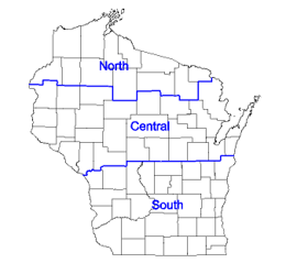 |
| Figure G-3 Wisconsin SPC Zones and Counties |
While C&GS/NGS mathematically designed the zones, states decided their jurisdiction limits. Keeping counties or parishes entirely within a single zone supported uniform surveying and mapping activities. This became increasingly important with adoption of geographic information systems at local jurisdictional levels.