G. State Plane Coordinates
1. General
The State Plane Coordinate (SPC) System has its origin in 1930's when the then named U.S. Coast and Geodetic Survey (C&GS) created a state-wide grid system for North Carolina using a conformal conic projection. Soon thereafter, C&GS created one or more zones for each state. Depending on physical configuration, a conic or transverse cylindric projection, or a combination, was used.The lone exception was the Alaska panhandle which used an oblique cylindric projection. Projections were conformal to preserve angular relationships.
Figure G-1 shows the original SPC zones developed for NAD27 and based on the Clarke 1866 ellipsoid.
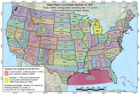 |
| Figure G-1 NAD 27 State Plane Coordinate Zones source: geodesy.noaa.gov/SPCS/maps.shtml |
Michigan actually had two sets of state plane coordinate systems: One using three conic projections and a second using three transverse cylindric. The conic projections were fit to an elevation 800 feet above sea level (and consequently the Clarke 1866 ellipsoid because there was no separation between geoid and ellipsoid for NAD 27). This was done to eliminate the ground to ellipsoid reduction since most of Michigan was within 200 feet of 800 ft elevation. Refer to Special Publication 65-3 Plane Coordinate Projection Tables Michigan, available in the NGS Publications Library.
When the NAD 83 horizontal datum was redefined and readjusted, SPC zones were re-referenced to the GRS 80 ellipsoid. Most zones stayed the same although there were some aggregation, Figure G-2.
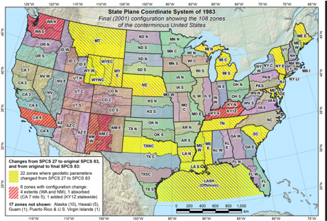 |
| Figure G-2 NAD 83 State Plane Coordinate Zones source: geodesy.noaa.gov/SPCS/maps.shtml |