2. Drawbacks?
Geographic coordinates are simple, but they do have some disadvantages.
a. Spherical trigonometry
(1) Distances
Distances between points are arcs, Figure B-2. Their lengths are angular and must be determined using spherical trigonometry.
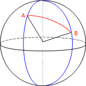 |
| Figure B-2 Arc Distance |
Survey distances are measured in linear units so another computational layer is added to make them work with geographic coordinates
(2) Angle Conditions
Multi-sided figures have curved sides and the Σ (interior angles)=(n-2)x180° angle condition does not apply, For example, the interior angle sum of triangle CDE in Figure B-3 can exceed 180°00'00".
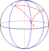 |
| Figure B-3 Spherical Triangle |
The amount by which the angle condition is exceeded is called spherical excess and accumulates at approximately 0°00'01" per 70 square miles of enclosed area.
b. Meridian convergence
(1) Directions
Meridians are parallel at the equator and converge to a point at the poles, Figure B-4
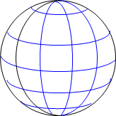 |
| Figure B-4 Convergence |
- Except for due east-west or north-south lines, forward and back directions are not exactly 180° degrees apart.
- Because they are perpendicular to meridians, east-west lines are curved not straight.
- A uniform angular difference between meridians is not uniform length. In Figure B-5, The longitude difference from G to F is the same as from K to J, but the arc distance GF is longer than KJ. This is true for any angle difference that is not along a meridian.
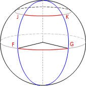 |
| Figure B-5 Length Variation |
c. The earth isn't round
Geographic coordinates are based on a sphere. Unfortunately the Earth is not spherical. A different geometric model is needed which complicates things. We still use latitude and longitude positions, but their geodetic counterparts, not geographic. This may seem a trifling difference, but it isn't, and will be covered in a subsequent chapter.