Page 1 of 2
B. Global Two-D Position
1. Definition
2D position reference is not limited to a flat plane. Geographic coordinates, latitude and longitude, have been used for centuries as an absolute positioning system. Sea bound navigators used flat paper maps which were plotted using latitude and longitude.
Assuming the Earth is a sphere, geographic coordinates are angular values with their verticies at the Earth's center, Figure B-1
- Latitude is the angle in the observer's meridian from the equator to the observer's vertical line. It varies from 0° at the equator to 90°N at the north pole and 90°S at the south pole.
- Longitude is the angle in the equatorial plane from the Greenwich Meridian (GM) to the observer's meridian. It varies from 0° at the GM to 180°E in the east direction and 180°W in the west.
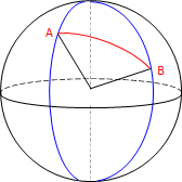 |
| Figure B-1 Geographic Coordinates |
As long as the directional suffixes are included, geographic coordinates are non-ambiguous.