Page 4 of 6
4. Ground Coordinates
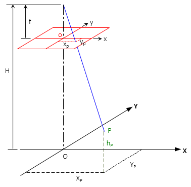
The photo coordinate system can be projected vertically to datum to create a local ground coordinate system, Figure C-8.
 |
| Figure C-8 Ground Coordinate System |
Directions of ground and photo axes are the same, origins coincide horizontally.
A point's ground coordinates are a function of its photo coordinates and scale, Equations C-3 and C-4:
 |
Equation C-3 |
 |
Equation C-4 |
If the tilt is excessive (>2°), the photo and ground coordinate systems will not be parallel introducing spatial error. The higher the flying height, the more pronounced the error.
Although the ground coordinate system is arbitrary based on the photo, coordinates can be transformed to a formal system if two or more control points appear on the photo.