C. Single Vertical Photo
1. Vertical Photography
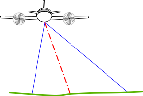
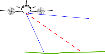
Most metric mapping photographs are vertical, where the camera's optical axis is within 2° of vertical. Images for interpretative and/or support purposes can be intentionally tilted: low- (does not contain horizon) or high- (contains horizon) oblique, Figure C-1.
 |
 |
| (a) Low oblique | (b) High oblique |
| Figure C-1 Tilted Photos |
|
Panoramic images can also be captured by rotating the lens from horizon-to-horizon perpendicular to the flight path.
The basic geometry of a vertical aerial image is shown in Figure C-2.
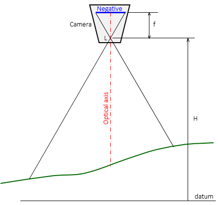 |
| Figure C-2 Vertical Photograph |
Where:
L is the optical center of the lens.
f is the focal length, the perpendicular distance from the lens center to the negative.
H is the height above datum.
The image is captured on the negative where color and optical geometry are reversed, Figure C-3.
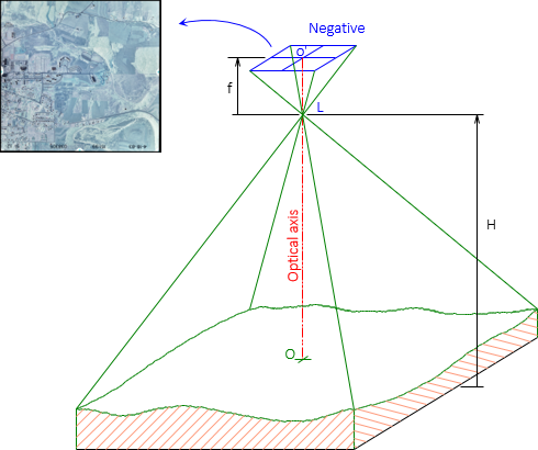 |
| Figure C-3 Negative |
A positive is a reversal of the negative; it's the image of the area we expect to see.
The physical size of the negative depends on the film used, usually 9" x 9" nominally for mapping. The positive may be larger or smaller depending on how it is produced. For most applications, a positive is created by contact printing making it the same size as the negative.
Using the same format sizes, Figure C-4 shows the addition of a positive to the geometry.
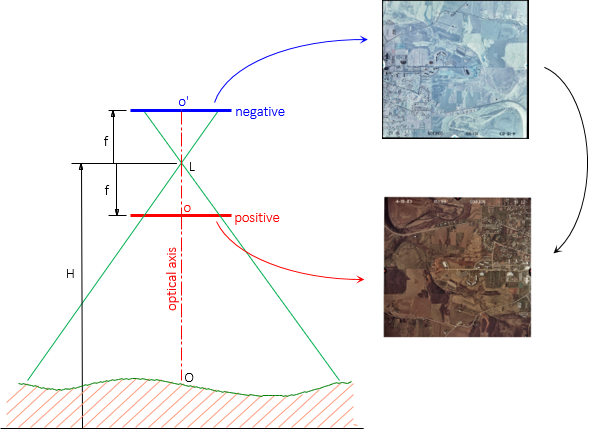 |
| Figure C-4 Positive |
2. Photo Coordinate System
Measurements can be made on the photo positive instead of the negative because they share the same geometry, including focal length. Connecting fiducial marks defines the photo coordinate system, Figure C-5.
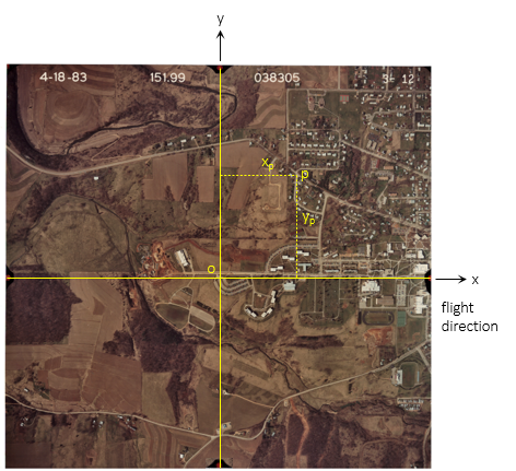 |
| Figure C-5 Photo Coordinate System |
The positive x-axis is in the direction of flight with positive y-axis to the left. The principal point, o, is at the intersection of the two axes, coinciding with the coordinate system origin. For basic measurements, the axes are assumed perpendicular. Camera calibration data may indicate otherwise, in which case axes non-orthogonality may need to be accounted for.
3. Scale
Although an aerial image looks like a map, it's not unless it's been converted to an orthophoto. Orthophotography is covered in a later chapter of this topic.
a. Point Scale
Scale is a proportion between the representation of an object and the object's real size. The closer the object is to the camera, the larger it will appear - it has a larger scale than objects further away. On a vertical image, scale is a function of elevation, camera height, and focal length, Equation C-1.
 |
Equation C-1 |
|
Si - Scale at point i |
|
Photo scale for points A and B in Figure C-6 are not the same because their elevations differ.
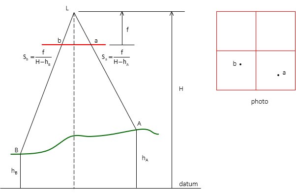 |
| Figure C-6 Point Scale |
b. Linear Scale
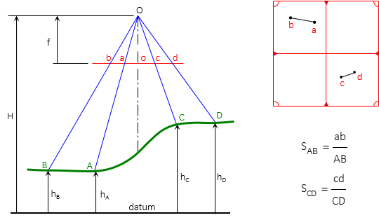
If two points have the same elevation and their horizontal ground distance is known, the linear scale between them can be computed with Equation C-2.
 |
Equation C-2 |
Figure C-7 shows the geometry of scale determination for two different coordinate pairs.
The linear scale is only correct at the elevation of the end points. If the terrain elevation decreases or increases between end points, so does the scale. Equation C-2 is useful only for flat terrain or over very short distances.
 |
|
Figure C-7 Linear Scale |
4. Ground Coordinates
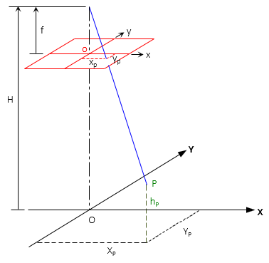
The photo coordinate system can be projected vertically to datum to create a local ground coordinate system, Figure C-8.
 |
| Figure C-8 Ground Coordinate System |
Directions of ground and photo axes are the same, origins coincide horizontally.
A point's ground coordinates are a function of its photo coordinates and scale, Equations C-3 and C-4:
 |
Equation C-3 |
 |
Equation C-4 |
If the tilt is excessive (>2°), the photo and ground coordinate systems will not be parallel introducing spatial error. The higher the flying height, the more pronounced the error.
Although the ground coordinate system is arbitrary based on the photo, coordinates can be transformed to a formal system if two or more control points appear on the photo.
5. Relief Displacement
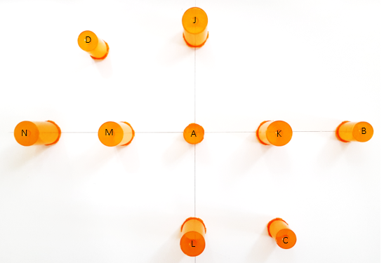
Figure C-9 is an overhead picture of nine vertical cylinders on a flat surface. Cylinders A-D are the same size; J-N are 25% wider and taller. The picture was taken centered on cylinder A and approximately 30 inches above.
 |
|
| Figure C-9 Overhead Photo of Cylinders |
On the picture we see that:
- Cylinder A is the only one whose top is directly over its bottom, the other cylinders lean away from A with their tops displaced outward.
- Cylinders J and L are approximately the same distance from A; their tops shift the same amount but in opposite directions; cylinders K and M behave similarly.
- Cylinder N is twice the distance from A as M; its top shifts about twice M's.
- Cylinders B and N are the same distance from A; B is shorter and its top shift is slightly less than N's.
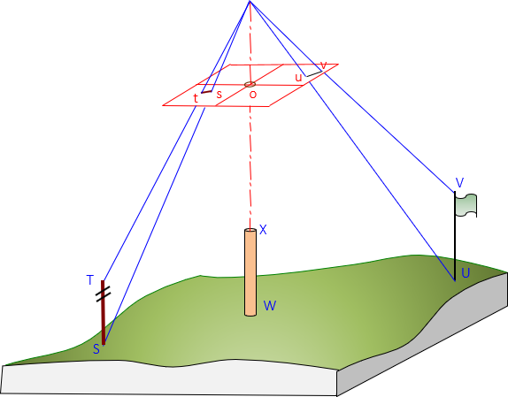
Relief displacement is the radial offset from the principal point due to object height, Figure C-10. The amount of displacement is a function of an object's height and where it appears on the image.
 |
| Figure C-10 Relief Displacement |
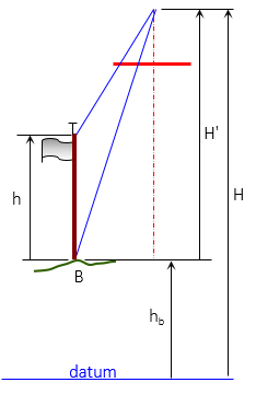
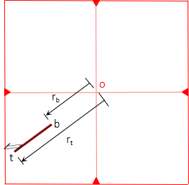
Relief displacement can be used to determine object heights, Figure C-11. The top and bottom of the object must be visible on the photo and the top must be vertically above the bottom.
 |
 |
| (a) Object | (b) Measurements |
| Figure C-11 Height from Relief Displacement |
|
Height is determined using Equation C-5
 |
Equation C-5 |
|
h - object height above ground |
|
6. Examples
Example (1)
Photography was taken with a 6.00 inch focal length camera flown at an height of 3500 ft above datum. Appearing on the photo are points J and K, whose elevations are 812.1 ft and 887.9 ft respectively. What are the photo scales at those points?
Solution

Example (2)
The elevation of points S and T is 703.6 ft and horizontal distance between them is 455.0 ft. The photo distance between the same two points is 32.1 mm. If the focal length of the camera used is 153.67 mm what was the flying height of the camera?
Solution
Set up Equation C-2
![]()
Set up Equation C-1

Set them equal to each other and solve the flying height
Example (3)
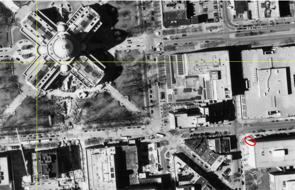
Figure C-12 is a portion of a Wis Dept of Trans aerial photo of Madison, WI. The camera's focal length was 152.265 mm (calibrated), flying height 3790 ft, and photo size 9 in by 9 in..
 |
| Figure C-12 Madison Aerial Photo |
The yellow lines connect opposite side fiducials, their intersection is the principal point. The large four-wing structure is the state capitol building and almost coincides with the principal point.
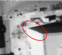
At the lower right of the image, a building edge is circled in red, Figure C-13 shows a magnified view.
 |
| Figure C-13 Building Detail |
Measured distances from the principal point to the bottom and top of the building edge are 55.03 mm and 56.80 mm. The area around the building is relatively flat with an elevation of 920 ft.
What is the building height?
Solution:

Example (4)
Two control points were targeted so they would appear in the aerial photography. Their Dane County Coordinates and elevations are:
| Point | North (ft) | East (ft) | Elev (ft) |
| T101 | 481,453.94 | 818,331.87 | 852.80 |
| T102 | 481,982.17 | 820,906.02 | 917.99 |
Their photo coordinates were measured
| Point | x (mm) | y (mm) |
| T101 | -57.58 | 49.02 |
| T102 | 64.37 | -15.18 |
The calibrated focal length of the camera was 152.265 mm.
What was the flying height?
There are two ways to compute flying height with the provided information: (1) Scale and (2) Ground Coordinates.
Scale Method

Compute photo (d) and ground (D) distances from the coordinates. Use the average elevation for the line between control points.


![]()
Re-sort scale equation to solve for H:
![]()

Flying height, H, is 3790 ft
Using Ground Coordinates.
Ground coordinates are related to photo coordinates by the scale. The ground coordinates we have for the control points are not based on the photo so we can't just solve equations C-3 and C-4 backwards to get H. The ground distance between the control points is the same wether we use the Dane County or photo Ground coordinates.
The inverse distance equation in terms of photo Ground coordinates is:
![]()
Substitute in Equations C-3 and C-4 and sort terms:

Since we know D=2627.789 ft by inversing Dane Co coords, the only unknown is H.
Input the numbers we know:

We're left with a second degree polynomial which requiring a quadratic solution:

Of the two possible answers, 3790 is the one that makes sense.
Flying height, H, is 3790 ft
Which is the right answer?
In this case, both methods gave the same result. Technically, the Ground Coordinate method is better because the Scale method uses an average elevation. If there were a substantial elevation difference between endpoints, using an average might introduce an error.
