Problem (2)
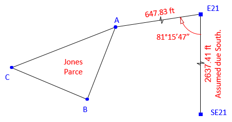
The survey of a remnant parcel was referenced the east line of the southeast quarter of Section 21, line E21-SE21. For project coordinates, the surveyor assumed 10,000.00 ft N and 6,000.00 ft E for point E21 and due South for the direction of line E21-SE21. At point point E21 he measured 2637.41 ft to point SE21, 647.83 ft to point A, and 81°15'47 angle right to point A.

Post-adjustment coordinates of the remnant parcel corners were:
|
Point |
North (ft) |
East (ft) |
|
A |
9901.596 |
5359.688 |
|
B |
9668.352 |
5270.827 |
|
C |
9771.088 |
5034.135 |
The Regional Planning Commission (RPC) GIS system is based on a multi-county coordinate system using metric units. Its coordinates for points E21 and SE21 are:
|
Point |
North (meters) |
East (meters) |
|
E21 |
43,827.359 |
19,231.752 |
|
SE21 |
43,023.821 |
19,200.333 |
Using a coordinate transformation, determine the bearing (to 01") and length (to 0.001 meter) of each remnant parcel line expressed in the RPC GIS coordinate system.