Solutions: COGO Intersections & Transformations
Problem (1)
To determine the horizontal distance between the tip of a lightning rod atop a smokestack (LR) to the top of a tall flagpole (FP) a surveyor used two instrument setups (1 and 2) and measured the horizontal angles shown on the diagram. She also measured the horizontal distance between the two instrument locations as 552.36 feet.
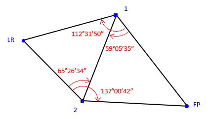
Using these measurements, what is the horizontal distance from the lightning rod to the flagpole?
Solution
Problem (2)
The survey of a remnant parcel was referenced the east line of the southeast quarter of Section 21, line E21-SE21. For project coordinates, the surveyor assumed 10,000.00 ft N and 6,000.00 ft E for point E21 and due South for the direction of line E21-SE21. At point point E21 he measured 2637.41 ft to point SE21, 647.83 ft to point A, and 81°15'47 angle right to point A.
![]()
Post-adjustment coordinates of the remnant parcel corners were:
|
Point |
North (ft) |
East (ft) |
|
A |
9901.596 |
5359.688 |
|
B |
9668.352 |
5270.827 |
|
C |
9771.088 |
5034.135 |
The Regional Planning Commission (RPC) GIS system is based on a multi-county coordinate system using metric units. Its coordinates for points E21 and SE21 are:
|
Point |
North (meters) |
East (meters) |
|
E21 |
43,827.359 |
19,231.752 |
|
SE21 |
43,023.821 |
19,200.333 |
Using a coordinate transformation, determine the bearing (to 01") and length (to 0.001 meter) of each remnant parcel line expressed in the RPC GIS coordinate system.