Page 3 of 3
3. Control Data
Jerry, Figure J-2, is NSRS control point NH0936 set in 1983 (by yours truly) as part of the first GPS network in Wisconsin.
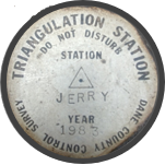 |
| Figure J-2 Jerry |
Figure J-3 is geodetic and grid data from Jerry's NSRS datasheet.
 |
| Figure J-3 Jerry Spatial Data |
Jerry was included in the NAD 83 (2011) adjustment and has grid coordinates in:
Wis South SPC zone - Lambert conic projection; survey feet (sFT) and meters (MT)
UTM 16 - Transverse Mercator cylindric projection; meters (MT)
Scale Factors and Convergences differ for SPC and UTM since they are two different grid systems. The Elevation Factor is the same because it represents distance distortion from Jerry's elevation to the ellipsoid which is grid-independent.