Page 2 of 3
2. Platforms
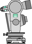
Image capture may be done from an aerial or terrain platform, although the former is more common for mapping applications. Terrain-based platforms are typically used in architectural applications where vertical or overhanging surfaces are not visible in detail to an airborne system. A terrain system may consist of a camera with a simple sighting attachment or a more complex and flexible photo-theodolite. A photo-theodolite combines a camera with theodolite allowing accurate camera orientation in the horizontal and vertical planes. Figure A-2 shows a very rough rendition of a photo-theodolite.
 |
| Figure A-2 Photo-theodololite |
This topic will deal only with aerial photography as that is the platform most surveyors will likely encounter.