A. General Concepts
1. Capture Technology
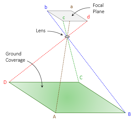
Traditional photogrammetry used film-based cameras. These have been largely replaced with digital cameras where the film is replaced with an array of detectors. In either case, the camera relies on a lens system to capture an image onto the focal plane, Figure A-1.
 |
| Figure A-1 Image Capture |
2. Platforms
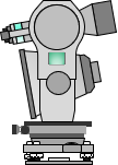
Image capture may be done from an aerial or terrain platform, although the former is more common for mapping applications. Terrain-based platforms are typically used in architectural applications where vertical or overhanging surfaces are not visible in detail to an airborne system. A terrain system may consist of a camera with a simple sighting attachment or a more complex and flexible photo-theodolite. A photo-theodolite combines a camera with theodolite allowing accurate camera orientation in the horizontal and vertical planes. Figure A-2 shows a very rough rendition of a photo-theodolite.
 |
| Figure A-2 Photo-theodololite |
This topic will deal only with aerial photography as that is the platform most surveyors will likely encounter.
3. Classes
Photogrammetry can be broadly divided into two overlapping classes: metric and interpretive.
Metric photogrammetry supports measurements to determine relative or absolute spatial positions in one-, two, and three-dimensions. Image distortion must be carefully controlled or camera calibration parameters known to apply systematic corrections.
The primary emphasis of interpretive photogrammetry is determination of objects and patterns on the image: land forms, land cover, land use, watersheds, erosion, etc. While spatial location is still important, image quality and clarity is paramount.
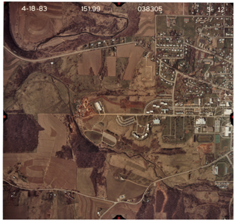
The two are not necessarily mutually exclusive as most aerial photographs can be used for both purposes. Figure A-3 is a Wis Dept of Transportation aerial photo of University of Wis-Platteville campus' western side.
 |
| Figure A-2 UW-Platteville Campus |
From an interpretive perspective, there are a lot of readily identifiable patterns: field types, buildings, waterways, roads and parking lots, etc. Near the center of the image is the city sewage treatment plant under construction at the time of the photography. A track and a stadium at the lower right and a cemetery at center right (yes, we have a cemetery in the middle of campus).
Along the sides at the middle of the frame edges (except the lower edge which got cut off in the scan) are some orange index marks. These are fiducial marks which are part of the camera and define the photo's coordinate system. These support the metric aspects of the photograph allowing us to determine things like distances, building heights, areas, etc. More on these in a later chapter.
The photo was taken in early spring (April 1983) before leaves appeared on the trees and field crops emerged. This is advantageous for metric applications but maybe not so much interpretive. Ground cover can't be identified nor can different tree types.
Higher altitude photography covers more area, things are smaller and closer together making them more difficult to interpret as well as accurately measure. Lower flying height improves both but at greater cost because more photos are needed to cover the same area - halving the flying height quadruples the number of photos of the same area.