1. All Maps
Whatever the type, whether manually or digitally produced, there are some parts common to all maps.
a. Title or Name
The title should be descriptive of map content. The title may be up the map compiler, or may be defined by policy, or, in the case of a legal map, by law.
A United State Geologic Survey (USGS) 7-1/2 minute topographic quadrangle (topoquad) is named after a local community or prominent feature. Figure B-1 is the topquad which contains Cuba City Wisconsin.
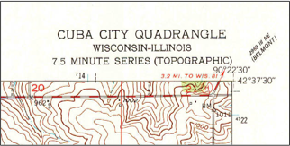 |
| Figure B-1 Topoquad Title |
In Wisconsin, a Certified Survey Map (CSM) must be so identified. When the map is recorded, it is assigned a sequential number which creates a unique name for the map, Figure B-2.
 |
| Figure B-2 CSM Title |
The title is also required to identify the Public Land System (PLS) quarter-quarter Section within which the CSM is located.
A map title may include the map's purpose, Figure B-3.
 |
| Figure B-3 Map Title |
b. Graphic Elements
Because it is an abstraction, a map depends on graphic elements to portray features: symbols, line types, and colors. These serve as graphic shorthand allowing complex features to be shown in simplified form and allow quick visual interpretation.
Figure B-4 is a portion of a Wisconsin Department of Transportation (WIDOT) State Highway map.
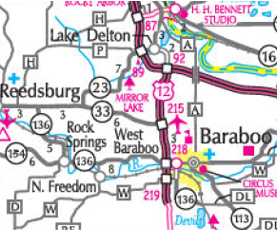 |
| Figure B-4 Wis State Highway Map |
Roads are shown as linear elements. Their line type, size, and color communicate different road classifications. Roads are in their correct planimetric location, but sizes are exaggerated for interpretive purposes; if plotted at actual widths all would appear as faint lines.
Figure B-4 also uses symbols for point features. Some are immediately recognizable, like the plane for an airport. Others may not be obvious: hollow triangle, solid square, solid square with a pennant, etc. For a map to be effective, the user must understand what its symbols represent. For that, a legend is used. The legend includes all map symbols, linear elements, colors, etc, and what they mean. Figure B-5 is the legend for Figure B-4.
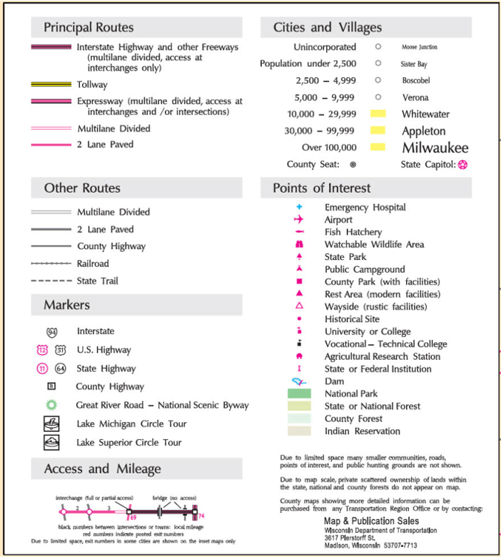 |
| Figure B-5 WIDOT State Highway Map Legend |
Legend content and complexity are a function of the graphic elements used on the map. It can be lengthy, like Figure B-5, or short, like Figure B-6 from a legal map.
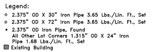 |
| Figure B-6 Legend from a Legal Map |
If a short legend is used, the map may need other support information to ensure graphics are correctly interpreted.
c. Orientation
Orientation is the map content relationship to north. Most people assume north is "up" on a map held upright. A North Arrow must be included on a map so the user does not have to assume. Figure B-7 is the North Arrow from the WIDOT State Highway map.
 |
| Figure B-7 WIDOT State Highway Map North |
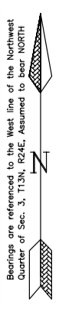
Unfortunately, there isn't a single "north"; there's geodetic, true, magnetic, grid, even assumed. Which is Figure B-7 based on? When orientation is given on a map, so should its basis. The North Arrow in figure B-8 is from a legal map and uses an assumed direction for a particular quarter Section line.
 |
| Figure B-8 North from a Legal Map |
Figure B-9 shows three different Norths on a map and their angular relationships.
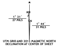 |
| Figure B-9 Multiple Norths |
GN: Universal Transverse Mercator (UTM) Grid North
MN: Magnetic North
*: Astronomic North
Because it changes irregularly over time, Magnetic North is rarely used as the only orientation for a map.
d. Scale
Scale is the relationship between a feature's size on a map and its actual size. A map should have a uniform scale in all directions: one unit in the x direction on the map represents the same ground distance as one unit in the y direction.
Scale can be expressed as a statement or graphically, examples of which are shown in Figure B-10.
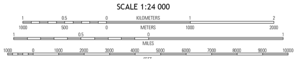 |
| Figure B-10 Scale Examples |
In traditional manual drafting, scale was an important initial consideration because reality had to be reduced to fit on a physical piece of paper. In a modern digital mapping environment where everything is drawn full-size, it would seem that scale isn't a consideration, but it is.
Scale is extremely important in map compilation and data collection. The next chapter discusses scale in greater depth.