A. Terms
1. General
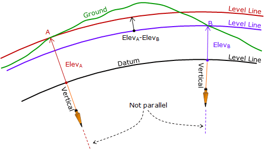
Refer to Figure A-1 for illustration of general terms. Some of these were defined in the Basic Principles topic; we will add some elevation terms.
 |
| Figure A-1 General Elevation Terms |
a. Level line
A line which is perpendicular to the direction of gravity (vertical) along its entire length. Because vertical lines converge, a level line is a curved line.
b. Level surface
A surface which, like a level line, is everywhere perpendicular to gravity. It is a curved surface.
c. Vertical datum
A level surface which serves as a datum for vertical distances.
Data can be formal or assumed. Formal data have some defining mathematical parameters and a network of physical marks (see Benchmark) allowing new points to be easily and accurately referenced. Examples of national data include Mean Sea Level (MSL), National Geodetic Vertical Datum of 1929 (NGVD28), and North American Vertical Datum of 1988 (NAVD88). Some regions and cities created and used local formal data before national data were widely available. An assumed datum is created for convenience and is not dependent on a formal datum. Elevations based on an assumed datum are correct relative to each other but not to elevations on other data.
d. Elevation
The vertical distance from a vertical datum.
e. Benchmark (BM)
A physical structure whose elevation with respect to a datum is known. It serves as a local reference to a datum allowing us to quickly determine elevations based on that datum.