{KomentoDisable}
Self Study: Coordinate Systems
Problem (1)
A PLS Section resurvey in northwestern South Dakota is referenced to that state's North SPC zone on NAD 83 (2011). After measurement adjustment, the SPC coordinates of a Section corner were determined to be 735,056.25 ft N, 1,002,231.06 ft E. The elevation of the point, scaled from a topquad is 825 ft; geoid height in this area of South Dakota is -15.6 m.
Using NCAT or the NAD 83 Coordinate Conversion workbook, determine the following for the Section corner
(a) South Dakota North SPC Zone convergence
(b) South Dakota North SPC Zone combined factor (CF)
(b) UTM Zone 13 coordinates in meters
Solution
Problem (2)
A survey in southwestern Missouri was referenced to the state's West SPC zone. The adjusted coordinates and scaled elevations of two surveyed points are shown in the following table.
| Point |
North (m) |
East (m) |
Elev (m) |
| Bobo |
63,690.932 | 916,159.330 | 445 |
| Nancy |
64,097.181 | 915,857.743 | 470 |
Geoid height in the project area is -28.7 meters.
What is the horizontal ground distance between the points?
Solution
Problem (3)
A survey in northern Wisconsin includes NSRS point QN0534 Brent. For direction orientation, NSRS point QN0533 Swayne Tower L is sighted from Brent. An angle of 212°55'14" is turned to the right to traverse point Dog. The measured horizontal distance from Brent to Dog is 1725.63 ft. Dog's scaled elevation is 1385 ft. The survey will be adjusted in Wisconsin's North SPC Zone in survey feet. Constants for the zone include No = 365,048.99 ft = 111,267.15 m, ro = 20,927,206.92 ft = 6,378,625.43 m.
(a) What is the geodetic azimuth from Brent to Swayne Tower L?
(b) What is the SPC grid azimuth from Brent to Swayne Tower L?
(c) Is there a significant arc-to-chord correction for the measured angle?
(d) What is the grid distance from Brent to Dog?
Solution
Problem (4)
Horizontal ground measurements for a survey in Tippecanoe County, Indiana, are shown below. The horizontal angles have been balanced to eliminate angular misclosure.
Using included control point LB2204 Morenci, the measurements will ultimately be reduced to Indiana's West SPC zone.
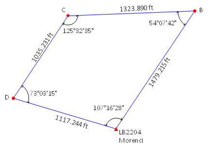
Might the angular misclosure be affected if arc-to-chord corrections are applied to the angles when reducing them to grid?
Solution
Problem (5)
Go to the NGS Survey Mark Datasheet site and select to Search By Station Name(s).
Find point Kollath in Wisconsin. You'll see six points with Kollath in their names. Get the datasheet for the one named Kollath alone without an RM # or Az Mk suffix.
Part (a) From the Current Survey Control section, record the following information:
| Datum/Adjustment | ____________ |
| Latitude | _______________ |
| Longitude | _______________ |
Part (b) From the Superseded Survey Control section, record the following information for the NAD 27 datum:
| Latitude | _______________ |
| Longitude | _______________ |
Part (c) Go to NGS NCAT page. Using NCAT, convert the NAD 27 geodetic coordinates to the datum/adjustment in Part (a) and record the reults below.
| Latitude | _______________ |
| Longitude | _______________ |
Part (d) Do the NCAT geodetic coordinates of Part (c) match the Current Survey Control geodetic coordinates from Part (a)? Why or why not?