{KomentoDisable}
B. Global Two-D Position
1. Definition
2D position reference is not limited to a flat plane. Geographic coordinates, latitude and longitude, have been used for centuries as an absolute positioning system. Sea bound navigators used flat paper maps which were plotted using latitude and longitude.
Assuming the Earth is a sphere, geographic coordinates are angular values with their verticies at the Earth's center, Figure B-1
- Latitude is the angle in the observer's meridian from the equator to the observer's vertical line. It varies from 0° at the equator to 90°N at the north pole and 90°S at the south pole.
- Longitude is the angle in the equatorial plane from the Greenwich Meridian (GM) to the observer's meridian. It varies from 0° at the GM to 180°E in the east direction and 180°W in the west.
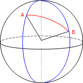 |
| Figure B-1 Geographic Coordinates |
As long as the directional suffixes are included, geographic coordinates are non-ambiguous.
2. Drawbacks?
Geographic coordinates are simple, but they do have some disadvantages.
a. Spherical trigonometry
(1) Distances
Distances between points are arcs, Figure B-2. Their lengths are angular and must be determined using spherical trigonometry.
|
| Figure B-2 Arc Distance |
Survey distances are measured in linear units so another computational layer is added to make them work with geographic coordinates
(2) Angle Conditions
Multi-sided figures have curved sides and the Σ (interior angles)=(n-2)x180° angle condition does not apply, For example, the interior angle sum of triangle CDE in Figure B-3 can exceed 180°00'00".
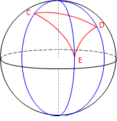 |
| Figure B-3 Spherical Triangle |
The amount by which the angle condition is exceeded is called spherical excess and accumulates at approximately 0°00'01" per 70 square miles of enclosed area.
b. Meridian convergence
(1) Directions
Meridians are parallel at the equator and converge to a point at the poles, Figure B-4
 |
| Figure B-4 Convergence |
- Except for due east-west or north-south lines, forward and back directions are not exactly 180° degrees apart.
- Because they are perpendicular to meridians, east-west lines are curved not straight.
- A uniform angular difference between meridians is not uniform length. In Figure B-5, The longitude difference from G to F is the same as from K to J, but the arc distance GF is longer than KJ. This is true for any angle difference that is not along a meridian.
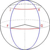 |
| Figure B-5 Length Variation |
c. The earth isn't round
Geographic coordinates are based on a sphere. Unfortunately the Earth is not spherical. A different geometric model is needed which complicates things. We still use latitude and longitude positions, but their geodetic counterparts, not geographic. This may seem a trifling difference, but it isn't, and will be covered in a subsequent chapter.