Solution: Coordinates
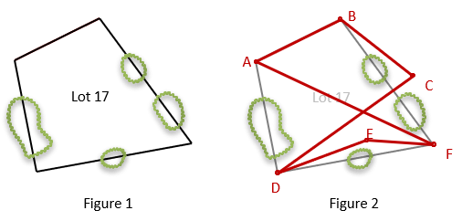
The owner of Lot 17 hires C. Gambino to survey his property, shown in Figure 1. Due to tree cover and other obstructions, Gambino is unable to run a closed traverse through successive adjacent property corners. He instead runs the closed traverse shown in Figure 2.

He completes the survey and reduces his measurements. His adjusted latitudes and departures are shown in the table:
Line |
Adj Lat |
Adj Dep |
AB |
+163.55 |
+327.07 |
BC |
-217.60 |
+279.76 |
CD |
-376.14 |
-525.02 |
DE |
+125.96 |
+346.75 |
EF |
-19.05 |
+258.40 |
FA |
+323.28 |
-686.96 |
Part (a)
Using 2000.00 ft N and 1000.00 ft E for A, determine the coordinates of the traverse points. Perform appropriate math check(s).
NB = NA + LatAB
EB = EA + DepAB
Start at A and compute back into it for a math check.
| A | 2000.00 | 1000.00 |
| +163.55 | +327.07 | |
| B | 2163.55 | 1327.07 |
| -217.60 | +279.76 | |
| C | 1945.95 | 1606.83 |
| -376.14 | -525.02 | |
| D | 1569.81 | 1081.81 |
| +125.96 | +346.75 | |
| E | 1695.77 | 1428.56 |
| -19.05 | +258.40 | |
| F | 1676.72 | 1686.96 |
| +323.28 | -686.96 | |
| A | 2000.00 | 1000.00 |
Part (b)
What are the bearings and distances for Lot 17's lines going clockwise around the parcel?
To compute line direction and distance using coordinates, use these equations:

|β| is the bearing angle; the signs on ΔN and ΔE determine the correct quadrant.
| Line |
ΔN |
ΔE |
L |
Quad |
β |
Brng |
| AB | +163.55 | +327.07 | 356.68 | NE | 63°25'58" |
N 63°25'58" E |
| BF | -486.83 | +359.91 | 605.42 | SE | -36°28'31" |
S 36°28'31" E |
| FD | -106.91 | -605.17 | 614.54 | SW | 79°58'53" |
S 79°58'53" W |
| DA | +430.19 | -81.81 | 437.90 | NW | -10°46'03" |
N 10°46'03" W |