Solution: Coordinate Systems
Problem (3)
A survey in northern Wisconsin includes NSRS point QN0534 Brent. For direction orientation, NSRS point QN0533 Swayne Tower L is sighted from Brent. An angle of 212°55'14" is turned to the right to traverse point Dog. The measured horizontal distance from Brent to Dog is 1725.63 ft. Dog's scaled elevation is 1385 ft. The survey will be adjusted in Wisconsin's North SPC Zone in survey feet. Constants for the zone include No = 365,048.99 ft = 111,267.15 m, ro = 20,927,206.92 ft = 6,378,625.43 m.
(a) What is the geodetic azimuth from Brent to Swayne Tower L?
(b) What is the SPC grid azimuth from Brent to Swayne Tower L?
(c) Is there a significant arc-to-chord correction for the measured angle?
(d) What is the grid distance from Brent to Dog?
Solution
Get the datasheets for Brent and Swayne Tower L.
(a) Geodetic azimuth from Brent to Swayne Tower L?
From Brent's datasheet:
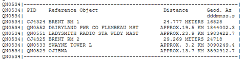
Geodetic Az = 309°02'49.4"
(b) SPC grid azimuth from Brent to Swayne Tower L?
Two ways to get
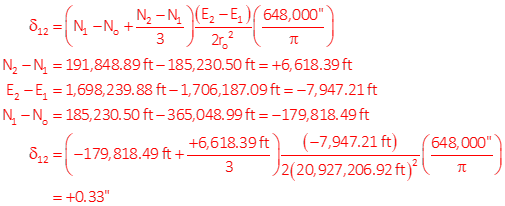
(1) Use convergence and geodetic azimuth at Brent
Brent is point 1; Swayne Tower L is point 2.
Compute arc-to-chord correction to see if it's significant
Compute grid az

(2) Inverse between SPC coords of the two points
Brent is point 1; Swayne Tower L is point 2.

Both ways get the same answer.
(c) Is there a significant arc-to-chord correction for the measured angle?
The BS correction was computed in the previous part: +0.33"
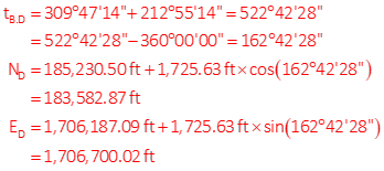
To compute the FS correction, need approx coords of Dog:
Compute FS correction
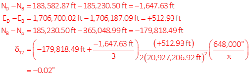
Determine total correction to angle

The angle correction is -0.35" which may not be significant for measurements, but can come into play for comps.

(d) Grid distance from Brent to Dog?
Using Brent's geoid ht and elevations of Brent and Dog, determine geodetic distance.
Different grid scale possibilities

Grid dist from Brent's scale, Brent and Dog average scale, weighted average; also, apply Combined Factor. Compare results.
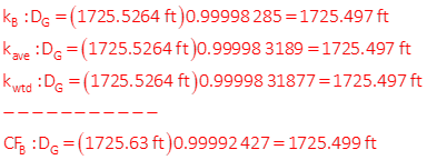
Grid Distance - 1725.497 ft