COGO Intersections and Curves
Problem 3
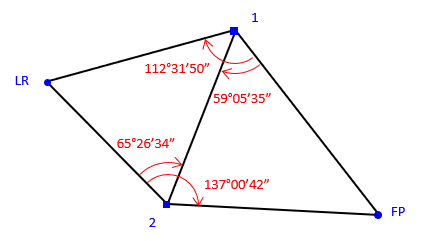
To determine the horizontal distance between the tip of a lightning rod atop a smokestack (LR) to the top of a tall flagpole (FP) a surveyor used two instrument setups (1 and 2) and measured the horizontal angles shown on the diagram. She also measured the horizontal distance between the two instrument locations as 552.36 feet.

Using these measurements, what is the horizontal distance from the lightning rod and to the flagpole?
Solution
(1) Forward calculation from point 1 to point 2
Assume coordinates for point 1 and an azimuth for line 1-2: we'll use 1000.00'N, 2000.00'E and 200°00'00"
Results: N2 = 480.951; E2 = 1811.082
(2) Direction-direction intersection to calculate point LR coordinates
Partial comps and results
Az1-LR = 200°00'00"+(112°31'50"-59°05'35") = 253°26'15"
Az2-LR = 200°00'00"-180°00'00"-65°26'34" = -45°26'34"+360°00'00"=314°33'26"
d1-LR = 573.754
NLR= 836.445; ELR= 1450.051
(3) Direction-direction intersection to calculate point FP coordinates
Partial comps and results
Az1-FP = 200°00'00"-59°05'35" = 140°54'25"
Az2-FP = 200°00'00"-180°00'00"+(137°00'42"-65°26'34") = 91°34'08"
d1-FP = 690.811
NFP= 463.846; EFP= 2435.613
(4) Inverse calculation between points LR and FP
Result: dLR-FP = 1053.642'