Do the computational problems using a calculator compatible with those allowed by NCEES. Fight the urge to use a computer, data collector, etc. The NCEES calculator list is at http://ncees.org/exams/calculator/
Problem (1)
|
A 6 inch focal length aerial camera was used to take vertical photography of relatively flat terrain having an average elevation of 870 feet. What is the scale of the photography if the plane was flying at an altitude of 2200 feet MSL? Express as 1 inch = XXXX feet, to nearest 10 ft. |
Problem (2)
|
T F At culmination, Polaris is due north of the observer. |
Problem (3)
|
T F An astronomic azimuth is the same as a geodetic azimuth. |
Problem (4)
|
An orthometric height is measured with respect to the:
(a) geoid
(b) ellipsoid
(c) spheroid
|
Problem (5)
|
A grid factor of 0.99995 is the same as a distortion of 1/____________ . |
Problem (6)
|
The maximum design distortion (ellipsoid to grid) for the original State Plane Coordinate systems is 1/____________ . |
Problem (7)
|
T F An azimuth determination using Polaris is generally more accurate than one using the Sun. |
Problem (8)
|
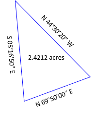
What are the lengths (to 0.01') of the sides of the following triangular parcel?
|
Problem (9)
|
T F On a pair of overlapping photographs, parallax is parallel with the flight direction. |
Problem (10)
|
T F At lower culmination Polaris is between the north pole and the observer's zenith. |
Problem (11)
|
The dimensions of a rectangular field are142.1 ft by 93.6 ft. What is the area of the field expressed to a reasonable level of accuracy:
Part (a) in square yards?
Part (b) in acres?
|
Problem (12)
|
The magnetic bearing of a property line was recorded as S 88º42' E in 1875. The magnetic bearing of the line today is S 84º10' E with a current declination of 1º10' W.
Part (a) What was the declination in 1875?
Part (b) What is the true bearing of the line?
|
Problem (13)
|
The bearing of line L to Q is S 23°15' W. The deflection angle at Q to M is 48°15' L. What is the bearing of the line Q to M? |
Problem (14)
|
An incoming +5.0% grade intersects an outgoing -4.0% grade at station 37+45.00 with an elevation of 1410.00 feet. A 800.00 foot long vertical curve will be fit between the two grade lines. What is the curve elevation at station 38+00.00? |
Problem (15)
|
The PI of an alignment is at station 45+24.00 with a deflection angle of 55º30'00” left. A 1000.00 ft radius curve is to be fit between the two horizontal tangents placing the PC at station at 39+97.87. At the PC, what are the deflection angle from the PC and the radial chord to curve station 44+00.00? |
Problem (16)
|
A survey crew using a TSI didn't know the temperature and pressure in the field so they set a 0 ppm correction in the instrument. They measured and recorded a horizontal distance as 823.42 feet. Later in the office, they determined the correction should have been -18 ppm. What is the corrected distance? Compute to 0.001'. |
Problem (17)
|
A reverse curve must be fit to the tangents shown below:
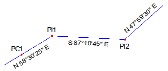 |
| Point |
Station |
| PC1 |
21+83.05 |
| PI1 |
27+35.80 |
| PI2 |
38+43.05 |
|
What are the radii of the two curves which fit this alignment? Compute to 0.01 ft.
|
Problem (18)
|
T F The voulme determined by Average End Area method between two different cross sections is too small. |
Problem (19)
|
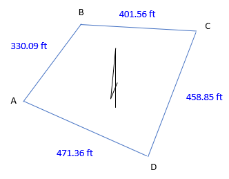
Given the traverse data, adjust the latitude and departure of line B-C by the Compass Rule (aka, Bowditch Rule).
|
|
|
Point
|
Int angle
|
|
A
|
75°36'06"
|
|
B
|
124°37'48"
|
|
C
|
71°24'36"
|
|
D
|
88°21'30"
|
|
sum
|
180°00'00"
|
|
| |
|
|
Unadjusted
|
|
Line
|
Azimuth
|
Length
|
Lat
|
Dep
|
|
A-B
|
37°42'06"
|
330.09
|
+261.169
|
+201.866
|
|
B-C
|
93°04'18"
|
401.56
|
-21.518
|
+400.893
|
|
C-D
|
201°39'42"
|
458.85
|
-426.446
|
-169.373
|
|
D-A
|
293°18'12"
|
471.36
|
+186.470
|
-432.908
|
| |
sums:
|
|
-0.325
|
+0.568
|
|
Problem (20)
|
The scale of a map is 1 in = 200 ft. What is the map scale expressed as a dimensionless ratio? |